Strain on Cape Town's disaster management as critical role remains unfilled
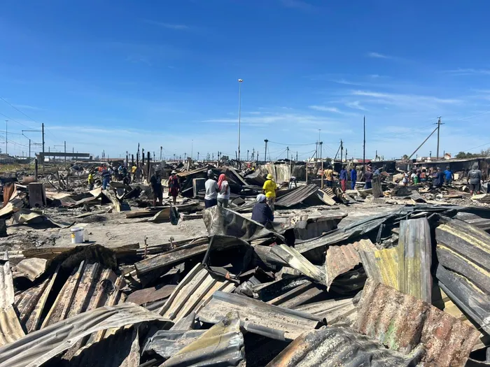
A devastating fire which swept through the Tsepe Tsepe Informal Settlement in Khayelitsha has left 377 people destitute.
Image: Gift of the Givers
Cape Town’s disaster management capacity is under pressure, with the City confirming that a key disaster management responsibility has remained vacant for more than a year while emergency incidents continue to be recorded across the metro.
The acknowledgement appears in the City of Cape Town’s Disaster Risk Management quarterly report for October to December 2025, which outlines disaster activations during the period and notes the prolonged vacancy within the disaster management function.
According to the report, the responsibility has been vacant for longer than 12 months, placing additional pressure on existing staff during periods of high operational demand.
Despite this, the City states via the report which has been seen by Cape Argus, that its disaster response systems remain operational. In the report, disaster management coordinating structures are described as “fully functional”, with incidents managed through established interdepartmental processes.
During the three-month reporting period, disaster teams were activated for a range of incidents, including informal settlement fires. Some incidents affected dozens of residents and resulted in homes being destroyed, leaving families displaced and reliant on emergency relief and temporary assistance. The report records incidents in areas including Overcome Heights, Imizamo Yethu, and parts of Mfuleni, highlighting the continued exposure of certain communities to recurring emergencies.
The pressures outlined in the report continued into the start of the year. During January, disaster management and emergency services were repeatedly deployed to fire-related incidents across Cape Town, including vegetation fires and residential blazes in areas such as Mowbray, Hout Bay and surrounding suburbs. Several incidents occurred during periods of high temperatures and strong winds, conditions that typically increase fire risk during the summer months.
In addition to vegetation fires, emergency services responded to incidents affecting residential areas, some of which posed threats to homes and infrastructure and required coordinated multi-agency responses. These January deployments formed part of routine emergency operations but underscored the sustained operational demands placed on disaster management structures outside of the winter flood season.
Alongside incident reporting, the City’s quarterly document includes a metro-wide disaster risk map identifying areas assessed as facing higher exposure to hazards such as fires and flooding. The map shows that several communities affected during the reporting period fall within zones identified as higher risk, reflecting patterns of repeat exposure rather than isolated events.
The risk map, structured by subcouncil and ward, forms part of the City’s broader disaster risk assessment and planning framework and is intended to guide preparedness and mitigation efforts ahead of seasonal threats, particularly winter rainfall, when flood risks typically increase in low-lying areas.
While the City outlines ongoing disaster planning initiatives, coordination forums and winter readiness preparations, the report’s reference to a prolonged vacancy has drawn attention to capacity pressures within the disaster management function at a time when the same areas continue to feature prominently in both incident records and risk assessments.
For residents living in identified high-risk zones, the report highlights the importance of effective disaster preparedness and coordination as the province moves through seasons associated with heightened fire and flood threats.
Get your news on the go, click here to join the Cape Argus News WhatsApp channel.
Cape Argus